The Longest Rivers in the World: The Nile, the Amazon, and a Measurement Fight
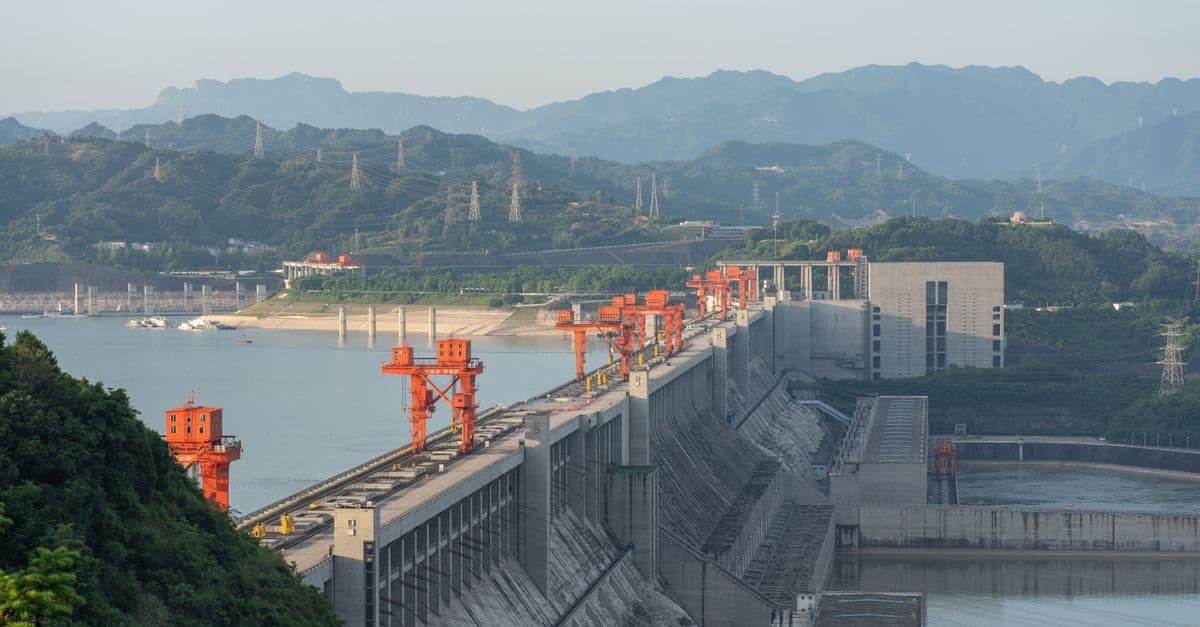
Photo: 高 长华 / Pexels
The Nile is traditionally ranked as the longest river in the world, at about 6,650 kilometres (4,130 miles) — but the Amazon, at roughly 6,400 km, is a serious and genuinely disputed challenger. Which one is truly longest depends on decisions that sound trivial and turn out to be anything but: where you say the river starts, and where you say it ends. Get those two decisions wrong, or simply make them differently than the last team, and the "correct" ranking flips.
This is a ranking with an asterisk, and the asterisk is the interesting part. Unlike most world records — tallest mountain, deepest trench, hottest recorded temperature — a river's length isn't a single physical quantity waiting to be read off an instrument. It's the end product of a chain of human decisions about where a natural, branching, shifting system "begins" and "ends." Understand that chain, and you understand why geographers have been arguing about this specific record since at least the 1950s, with no resolution in sight.
The Short Answer: Longest Rivers (Traditional Ranking)
Table 1. The world's five longest rivers by traditional length estimate.
| Rank | River | Length (approx.) | Continent | Outflow |
|---|---|---|---|---|
| 1 | Nile | 6,650 km (4,130 mi) | Africa | Mediterranean Sea |
| 2 | Amazon | 6,400 km (3,980 mi) | South America | Atlantic Ocean |
| 3 | Yangtze | 6,300 km (3,915 mi) | Asia | East China Sea |
| 4 | Mississippi–Missouri | 6,275 km (3,900 mi) | North America | Gulf of Mexico |
| 5 | Yenisei | 5,539 km (3,445 mi) | Asia | Kara Sea (Arctic Ocean) |
Every figure here is approximate — and that's not laziness. As you'll see, river lengths legitimately vary by source, sometimes by hundreds of kilometres, depending on the methodology used to trace them.
Why "How Long Is a River?" Has No Clean Answer
Measuring a river sounds like a job for a ruler, or in the modern version, a GPS track laid over satellite imagery. In practice, three decisions each shift the number by tens or hundreds of kilometres.
1. Where does it start? A river is fed by many tributaries, each of which is fed by smaller tributaries, in a branching structure that has no single obvious "trunk." By convention, hydrologists treat the "source" as the start of the longest continuous flow path to the mouth — but identifying which headwater stream is longest, often high in remote mountains where no gauge has ever been installed, is genuinely hard. The Amazon's accepted source has been relocated more than once as expeditions traced different Andean streams with GPS units and satellite mapping that simply didn't exist a generation ago.
2. Where does it end? Big rivers don't end at a neat point on a map. They fan into deltas, like the Nile's, or dissolve into vast tidal estuaries, like the Amazon's. Do you measure to the point where the river first splits into delta channels, or follow one specific channel out to the open sea? The Amazon's mouth is so wide — its estuary spans over 200 kilometres between Marajó Island and the mainland — that the choice of which channel to trace adds or subtracts real distance, sometimes more than 100 km.
3. How do you handle bends? A river meanders constantly, and meanders shift year to year as the channel erodes one bank and deposits sediment on the other. Measure along every small curve, using high-resolution satellite data, and you get a longer number than if you smooth the path to the resolution of an older topographic map. Different national mapping agencies use different levels of detail, and even the same agency's number can drift over decades as measurement technology improves.
Because each measurement team makes these calls slightly differently, there is no single official length for a major river — only ranges, published by different institutions using different conventions. This is exactly why reputable sources disagree, and why the Nile–Amazon question stays open despite over a century of dedicated field expeditions trying to settle it.
The Nile: Longest, by Tradition
The Nile flows northward for about 6,650 km through eleven countries — Tanzania, Uganda, Rwanda, Burundi, the Democratic Republic of the Congo, Kenya, Ethiopia, Eritrea, South Sudan, Sudan, and Egypt — before reaching the Mediterranean Sea at a broad delta near Cairo. Unlike most of the world's other major rivers, the Nile runs south to north, which is one reason its geography confused early European cartographers for centuries: rivers, in their intuition, were supposed to flow away from mountains toward the equator, not away from the equator toward the sea.
Its length comes from two great tributaries that merge at Khartoum, Sudan: the White Nile, whose ultimate source lies in the highland streams that feed Lake Victoria, and the Blue Nile, which begins at Lake Tana in Ethiopia and, despite being shorter, supplies roughly 80% of the Nile's total water volume during the flood season, largely from Ethiopian monsoon rains.
The Nile's claim to the "longest" title rests specifically on the long White Nile headwaters. A 2006 GPS-based expedition (the "Ascend the Nile Expedition") traced a source in the Nyungwe Forest of Rwanda, on a tributary of the Rukarara River, and used that survey to push some length estimates for the Nile as high as roughly 6,700–6,750 km — even longer than the traditionally cited 6,650 km figure. But because the White Nile's headwaters wind through a maze of equatorial lakes and the vast Sudd wetland in South Sudan — a swamp so large and so flat that the river's exact channel through it shifts seasonally — exactly where the Nile "begins" is itself genuinely debatable. That ambiguity is precisely the opening that Amazon researchers have exploited to argue their river deserves the top spot instead.
The Nile's flow also connects to some of Earth's most extreme climates. Its Ethiopian headwaters sit in one of the wettest monsoon-fed highland regions on the continent, while its lower course crosses the hyper-arid Sahara, forming a striking contrast that echoes the driest and wettest places on Earth.
The Amazon: Biggest Beyond Dispute
While the Amazon's length title is contested, one record is not: the Amazon is by far the largest river on Earth by water volume, and it isn't close. Estimates of its discharge into the Atlantic Ocean typically range from about 215,000 to 230,000 cubic metres per second on average, according to hydrological surveys compiled by the U.S. Geological Survey and university river research groups, and that flow can surge to roughly 300,000 cubic metres per second during the rainy season. By comparison, the Nile's average discharge is only around 2,800–3,000 cubic metres per second — a gap of nearly two orders of magnitude.
Put another way: NASA's Jet Propulsion Laboratory, using a 2021 methodology that combined stream-gauge data with computer models of roughly 3 million river segments worldwide, found that the Amazon basin alone contains about 38% of all the water flowing through the world's rivers at any given moment, more than any other hydrologic region on Earth. Separate estimates suggest the Amazon supplies somewhere between 15% and 20% of all the freshwater that reaches the world's oceans from rivers — a single river basin accounting for roughly a fifth of the planet's entire river-to-ocean freshwater budget.
That dominance exists because the Amazon drains the largest and wettest river basin on the planet, a basin fed by the world's largest tropical rainforest and by moisture pumped in from the Atlantic that gets recycled repeatedly as it crosses the forest canopy. Length is a coastline-style measurement problem, sensitive to arbitrary choices about resolution and endpoints; volume is comparatively unambiguous, because it's tied to the actual physical quantity of water moving past a gauge station, and on volume the Amazon wins so decisively that no other river is in the conversation.
The length dispute itself has a specific modern history. In 2014, American neuroscientist and explorer James "Rocky" Contos proposed that the Amazon's true hydrological source lies not at the previously accepted glacier in southern Peru, but at a stream on Nevado Mismi or a nearby peak that, when traced by satellite imagery and GPS-verified field survey, adds meaningful extra distance to the river's total length. Since then, several expeditions — including a widely reported 2023 team effort aiming to settle the debate definitively — have traced new Andean source candidates and measured to a southern channel of the mouth near Marajó Bay, producing Amazon length figures that exceed the Nile's traditional 6,650 km. Other research teams, using the older, more conservative source point and a more central mouth channel, keep the Nile ahead. Both groups can be "right" by their own conventions — they are answering subtly different versions of the same question.
Does the Amazon carry more species than any other river system?
Yes. The Amazon basin is home to an estimated 2,500 to 3,000 known fish species, roughly ten times the number found in the Mississippi basin, along with freshwater specialists found nowhere else, including the Amazon river dolphin (the boto), the largest freshwater dolphin species on Earth, which can reach about 2.5 meters (8.2 ft) in length. The basin's biodiversity outstrips its rivals for the same reason its water volume does: sheer basin size and unbroken tropical rainfall.
The Yangtze: Asia's Undisputed Longest, Ranked Third Worldwide
The Yangtze is the longest river in Asia and the longest confined entirely within a single country, running roughly 6,300 km from its source on the Tibetan Plateau to its mouth at the East China Sea near Shanghai. Its headwaters lie in glacial meltwater and snowfields in the Tanggula Mountains of southern Qinghai Province, at elevations above 5,000 meters, making it one of the highest-altitude major river sources on Earth alongside the Yangtze's Himalayan cousins, the Mekong and the Indus.
Unlike the Nile or the Amazon, the Yangtze's length isn't seriously disputed among major sources, largely because its entire course sits within a single country with a long, centralized surveying tradition, and because its mouth resolves to a single well-defined estuary rather than a sprawling multi-channel delta. That relative certainty is itself an illustration of the earlier point: ambiguity in river-length measurement tends to cluster around rivers with either poorly mapped headwaters (the Nile, the Amazon) or extremely complex mouths (again, both of those rivers) — remove those two sources of ambiguity, and the number stabilizes.
The Yangtze's most consequential modern feature is the Three Gorges Dam, the largest power station on Earth by installed capacity. Construction began in 1992, and the reservoir began filling in June 2003; the dam itself stands roughly 181 meters (594 ft) tall and 2,335 meters (7,770 ft) long, with a reservoir that extends about 600 km (370 mi) upstream, submerging the narrow limestone gorges — the Qutang, Wu, and Xiling gorges — that gave the "Three Gorges" region its name. The dam displaced more than a million people during construction, one of the largest engineering-driven relocations in modern history, and it remains a case study in the trade-offs between hydropower capacity, flood control, and the ecological and cultural cost of remaking a major river's course.
Why doesn't a river's length change when a dam is built?
It usually doesn't, in the sense that mattersfor the ranking — a dam widens and slows the water without shortening the channel path from source to sea. The Three Gorges Reservoir raised water levels and submerged towns along a 600-km stretch, but the Yangtze's total length calculation from Tibetan glacier to East China Sea mouth stayed essentially unchanged, because length is measured along the historical channel path, not the current reservoir surface area.
Fourth and Fifth Place: Mississippi–Missouri and the Yenisei
The Mississippi–Missouri system is the longest river system in North America and the fourth-longest in the world when the two rivers are measured as a combined system, at roughly 6,275 km (3,900 mi). This combined figure is itself a measurement convention worth unpacking: the Mississippi alone, from its source at Lake Itasca in Minnesota to the Gulf of Mexico, runs about 3,766 km (2,340 mi). The Missouri River, its largest tributary, is actually slightly longer on its own — about 3,767 km (2,341 mi) from its source in the Rocky Mountains of Montana to its confluence with the Mississippi at St. Louis. Because the Missouri is longer than the Mississippi channel it joins, some hydrologists argue the "true" main stem should be named the Missouri-Mississippi, not the reverse — a naming dispute that echoes the Nile-White Nile source debate on a smaller scale.
Together, the Mississippi and Missouri drain about 3.1 million square kilometres (1.2 million sq mi) — roughly one-eighth of the continental United States, spanning parts of 31 U.S. states and two Canadian provinces, according to the U.S. National Park Service. That drainage basin footprint places it among the largest river basins on Earth even though its total length trails the Nile, Amazon, and Yangtze by a considerable margin.
The Yenisei, at roughly 5,539 km (3,445 mi), is Russia's longest river and the largest river system draining into the Arctic Ocean. It rises in the Sayan Mountains near the Mongolian border and flows north through central Siberia, forming a rough dividing line between Western and Eastern Siberia, before emptying into the Kara Sea north of the Arctic Circle. The Yenisei's basin experiences some of the most extreme seasonal temperature swings of any major river system on Earth, freezing solid across much of its length for months at a time and then flooding dramatically each spring as the ice breaks up from south to north — a pattern that periodically causes the river's downstream sections to back up against ice still frozen further north, producing severe localized flooding events almost every year.
Table 2. Source-to-mouth comparison for the world's top five rivers.
| River | Approx. source elevation | Source region | Basin area (approx.) |
|---|---|---|---|
| Nile | ~2,000 m | Rwandan/Burundian highlands | 3.25 million km² |
| Amazon | ~5,000 m | Peruvian Andes | 7.05 million km² |
| Yangtze | ~5,000 m+ | Tanggula Mountains, Tibetan Plateau | 1.8 million km² |
| Mississippi–Missouri | ~2,800 m (Missouri source) | Rocky Mountains, Montana | 3.1 million km² |
| Yenisei | ~2,000 m | Sayan Mountains | 2.58 million km² |
Rivers and the Shape of the Land
A river's length is really a story about the terrain it crosses — the high points it falls from and the low basins it drains. The world's longest rivers all begin in major mountain systems (the Amazon in the Andes, the Yangtze on the Tibetan Plateau, the Missouri in the Rockies) and end at sea level, threading the gap between the highest and lowest points on Earth. That gap is enormous in absolute terms — Mount Everest's summit at 8,848.86 meters above sea level sits roughly 19.8 km above the floor of Challenger Deep — and every long river is, functionally, a slow-motion trace of gravity pulling water down that entire vertical range, compressed into a horizontal path that can run for thousands of kilometres before it finally levels out.
Where these rivers finally reach the ocean also connects them, indirectly, to the deepest places in the ocean: river deltas deposit enormous volumes of sediment onto continental shelves over geological time, sediment that eventually slides down submarine canyons into the deep ocean basins, feeding some of the largest sediment fans on Earth. The Amazon's underwater sediment fan alone extends for hundreds of kilometres across the floor of the Atlantic, a direct physical record of everything the river has eroded off the Andes and carried downstream over millions of years.
The relationship between elevation and river length also explains why river-length rankings are comparatively stable at the top and increasingly contested further down the list. The five rivers on the traditional top-five table drain some of the largest and most topographically well-defined basins on the planet; smaller rivers, with basins an order of magnitude smaller, tend to have length measurements that are easier to pin down precisely because there's less remote, poorly mapped terrain for the "true" source to hide in.
What Rivers This Long Actually Support
It's easy to treat "longest river" as a trivia category divorced from consequence, but length at this scale correlates with an enormous amount of downstream human and ecological dependence. The Nile basin alone supplies water, directly or indirectly, to roughly half a billion people across eleven countries, and Egypt in particular depends on the river for more than 90% of its freshwater supply, according to United Nations water resource assessments, despite receiving almost no direct rainfall across most of its territory. The 2011–2023 dispute over Ethiopia's Grand Ethiopian Renaissance Dam on the Blue Nile — which threatened to reduce downstream flow to Sudan and Egypt during the reservoir's filling period — is a direct geopolitical consequence of exactly the hydrological fact discussed above: the Blue Nile supplies the majority of the Nile's total water despite being the shorter of its two great tributaries.
The Amazon basin, meanwhile, holds roughly 20% of the world's identified plant, insect, bird, and mammal species within a single river system's drainage area, according to estimates cited by international conservation bodies, making its combined length-and-volume dominance a proxy for its status as the single most biodiverse terrestrial-freshwater system on the planet. Deforestation across the basin has become one of the most closely monitored environmental indicators globally precisely because the Amazon's discharge, evaporation, and rainfall recycling processes influence weather patterns far beyond South America — moisture that evaporates from the rainforest canopy is carried by prevailing winds and contributes measurably to rainfall as far away as the U.S. Midwest, according to atmospheric modeling research published over the past two decades.
The Yangtze, by contrast, illustrates a different kind of dependency: engineered dependency. Roughly a third of China's population lives within the Yangtze basin, and the river accounts for a substantial share of the country's freshwater withdrawal, grain production, and — since 2012, when the Three Gorges Dam reached full operational capacity — hydroelectric generation. A single river system, in other words, can simultaneously be a length-ranking curiosity and a load-bearing piece of national infrastructure for over a billion people.
Common Confusions: What People Get Wrong About "Longest River"
"Longest" and "biggest" are treated as synonyms, and they aren't. As shown above, the Amazon loses the length argument (by some measurement conventions) but wins the volume argument by an overwhelming margin. A river can be "the biggest" in terms of the water it carries while being shorter, on paper, than a river that carries a tiny fraction of that flow. The Nile, despite its 6,650-km length, has a drainage basin smaller than the Congo River's, and a discharge smaller than dozens of rivers most people have never heard of.
People assume a "final answer" exists somewhere in an official government database. It doesn't. There is no single international standards body — no equivalent of the Bureau International des Poids et Mesures that defines the meter — that certifies official river lengths. Figures come from national geological surveys, university expeditions, and encyclopedia editorial teams, each applying their own source-and-mouth conventions, which is exactly why you'll see the Nile's length cited anywhere from 6,650 km to nearly 6,853 km depending on which source you check.
People assume the ranking is static. It isn't, for two separate reasons. First, measurement technology keeps improving — GPS-verified field surveys and high-resolution satellite imagery in the 2000s and 2010s have repeatedly revised earlier 20th-century estimates, sometimes by hundreds of kilometres, as with the Nile's Rwandan source expedition. Second, rivers themselves change gradually: channels shift, deltas grow or erode, and in a few documented cases (particularly for rivers subject to significant human engineering, like canal diversions or reservoir construction) the physical length of the flow path has measurably changed within living memory.
People confuse "longest" with "widest" or "with the largest delta." The Amazon's estuary, at over 200 km wide, is frequently mistaken for the river's mouth width in a simple sense, but much of that width includes islands, side channels, and areas that are only water during high tide or flood season — which is exactly the kind of ambiguity that makes "where does the river end" such a genuinely contested question rather than a simple oversight by careless cartographers.
Frequently Asked Questions
Q: What is the longest river in the world? A: Traditionally the Nile in Africa, at about 6,650 km, with the Amazon in South America second at roughly 6,400 km. However, the ranking is genuinely disputed — some 21st-century studies, including a 2006 GPS survey of a Rwandan source and multiple Amazon source-tracing expeditions since 2014, have produced figures that put the Amazon ahead. There is no single official figure because river length depends on how you define the source and mouth.
Q: Is the Amazon longer than the Nile? A: Possibly — it depends on the measurement conventions used. Several expeditions tracing different Andean source streams (including the 2014 Contos survey and follow-up expeditions through the 2020s) and measuring to a southern mouth channel have found the Amazon longer than the Nile, while other methods using more conservative source and mouth choices keep the Nile ahead. What is undisputed is that the Amazon is the world's largest river by water volume, by an enormous margin.
Q: Why do sources give different lengths for the same river? A: Because measuring a river requires three judgment calls: which headwater counts as the true source, where the river "ends" in its delta or estuary, and how closely you trace its meanders using available imagery. Different agencies choose differently, so each major river has a range of accepted lengths rather than one exact number, and that range can span hundreds of kilometres for rivers with complex headwaters or deltas.
Q: What is the longest river in the United States? A: The Missouri River is the longest single river in the U.S. at about 3,767 km (2,341 mi), slightly longer than the Mississippi River it joins at St. Louis. Combined as the Mississippi–Missouri system, they form the fourth-longest river system in the world at roughly 6,275 km, draining about one-eighth of the continental United States.
Q: Which river carries the most water? A: The Amazon, without rival. It discharges an estimated 215,000 to 230,000 cubic metres of water per second on average into the Atlantic, according to USGS and university river-research surveys, rising to roughly 300,000 cubic metres per second during peak flood season — a figure widely cited as being close to as much as the next several largest rivers combined, and equal to somewhere between 15% and 20% of all freshwater that reaches the world's oceans from rivers.
Q: What is the longest river in Asia? A: The Yangtze, at approximately 6,300 km from its glacial source on the Tibetan Plateau to its mouth at the East China Sea. It is also the longest river confined entirely within a single country and home to the Three Gorges Dam, the world's largest power station by installed capacity.
Q: Has the "longest river" title ever officially changed hands? A: No encyclopedia, government geological survey, or scientific body has ever formally reclassified the Amazon as longer than the Nile in a way that's been broadly adopted; most major reference sources, including Britannica and the USGS, still list the Nile first. But the underlying research supporting an Amazon-first ranking has grown more credible since 2014, and the debate is treated as scientifically live rather than settled.
Q: Why does the Nile flow north instead of south? A: Rivers flow toward lower elevation, not toward the equator or away from it — the Nile's headwaters in the East African highlands sit at higher elevation than the Mediterranean Sea, so gravity carries the water north regardless of latitude. The pattern only seems unusual because most other famous rivers people learn about happen to flow toward the equator.
Q: Do dams like the Three Gorges Dam change a river's official length? A: Not meaningfully. A dam widens, slows, and raises the water level along a stretch of river, but length calculations follow the historical channel path from source to sea rather than the current reservoir surface, so major dam projects like the Three Gorges Dam have not altered the Yangtze's ranked length in reference sources.
Q: How many countries share the Nile River basin? A: Eleven: Tanzania, Uganda, Rwanda, Burundi, the Democratic Republic of the Congo, Kenya, Ethiopia, Eritrea, South Sudan, Sudan, and Egypt. This makes the Nile one of the most geopolitically complex river basins on Earth, since upstream dam projects in any one country can directly affect water availability for thousands of kilometres downstream.
The takeaway
The Nile-versus-Amazon dispute isn't a failure of measurement — it's an honest reflection of the fact that a river doesn't have a single, sharply defined start or end point the way a mountain has a summit or a trench has a floor. Every length figure you'll see cited is the output of specific, defensible choices about which headwater stream counts as the source and which channel counts as the mouth, and different careful teams have made those choices differently and arrived at different, equally legitimate answers. The one number in this whole comparison that isn't up for debate is the Amazon's water volume, which so dramatically outstrips every other river on Earth that no measurement convention could ever put another river ahead of it. Call it the Nile by tradition and the Amazon by volume, and treat "longest river in the world" as one of those rare records where the most accurate answer is a range, not a number.
Read next:
- The Driest and Wettest Places on Earth
- The Highest and Lowest Points on Earth
- The Deepest Places in the Ocean
Sources
- U.S. Geological Survey — Nile, Amazon, Mississippi, and Missouri river length and discharge measurements
- Encyclopædia Britannica — Nile, Amazon, Yangtze, and Yenisey river entries
- NASA Jet Propulsion Laboratory (2021) — "NASA-Led Study Provides New Global Accounting of Earth's Rivers"
- phys.org (2023) — "Which is longer, Amazon or Nile? New quest aims to settle old debate"
- Explorersweb — coverage of the 2014 Contos Amazon source expedition and subsequent surveys
- U.S. National Park Service — Mississippi River facts and drainage basin data
- World Wildlife Fund — Amazon river dolphin species data
- Britannica — Three Gorges Dam and Yangtze River construction and engineering details
Bottom line: Call it the Nile by tradition and the Amazon by volume — and accept that "longest river" is one of those records where the honest answer is a range, not a number.
Last verified: July 2026
Follow new articles
Add SciHub101 to your feed reader to see new science and technology stories.
About the Author
SciHub101 is an independent science and technology publication founded and edited by Buğra Sözeri, a software engineer and app developer based in Türkiye. AI tools assist with drafting and research. Source documentation in the existing archive is uneven, and articles are being reviewed and corrected. The Editorial Team byline identifies editorial responsibility; it does not certify specialist or independent human review. Where we compare products, anything built by our own team is labelled as such — see the editorial guidelines and About page for how corrections and disclosures work.
Related Articles
The Tallest Buildings in the World: Burj Khalifa and the Race to a Kilometre
At 828 metres, Dubai's Burj Khalifa has held the title of world's tallest building since 2010 — and as of 2026 nothing completed has come close. The runner-up, Kuala Lumpur's Merdeka 118, tops out at 678.9 metres, nearly 150 metres shorter. But the real story is the building rising in Jeddah: a tower designed to break one kilometre, a height engineers once argued was physically impractical. How tall can we actually build, and what stops us?
The Largest Deserts in the World: Why Antarctica Beats the Sahara
Ask most people to name the world's largest desert and they'll say the Sahara. They're wrong — and the reason why reveals what a desert actually is. A desert is defined by how little water falls from the sky, not by sand or heat. By that definition the single largest desert on Earth is Antarctica: a 14-million-square-kilometre sheet of ice that receives less precipitation than parts of the Sahara. The biggest deserts on Earth are frozen.
Biggest Cities in the World by Population: City, Metro, and Urban Area
Jakarta leads the UN's 2025 city ranking, yet Chongqing has more people inside its borders. See the biggest cities by city, urban area, and metro definition.
The Largest Countries in the World: Russia Spans Eleven Time Zones
Russia is so large that when the sun rises over its Pacific coast, much of the country is still in the previous day. At about 17 million square kilometres it covers more than an eighth of all the land on Earth — bigger than the surface of Pluto — and stretches across eleven time zones. The ranking of the world's biggest countries is a story of empires, frozen frontiers, and a map projection that quietly lies about who's really biggest.
The Longest Mountain Ranges in the World: The 65,000-Kilometre Range You'll Never See
The Andes stretch 7,000 kilometres down the spine of South America — the longest mountain range on land, and a wall so high it creates deserts on one side and rainforests on the other. But it's not even close to the longest range on the planet. That title belongs to a mountain chain ten times longer, winding 65,000 kilometres around the globe entirely beneath the oceans, where most of Earth's volcanic activity quietly happens.