What If Antarctica Completely Melted?
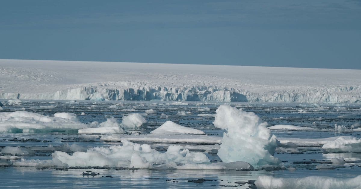
Photo: Francesco Ungaro / Pexels
Antarctica is the largest single reservoir of freshwater on Earth — a continent roughly the size of the United States and Mexico combined, buried under an ice sheet that averages about 1.9 kilometers (1.2 miles) thick. According to the National Snow and Ice Data Center (NSIDC), the Antarctic Ice Sheet contains close to 26.5 million cubic kilometers (6.4 million cubic miles) of ice, and if every bit of it melted, global sea level would rise by approximately 58 meters (190 feet). This is not a forecast. It is a thought experiment in extremes, built on real glaciology, that shows what the true ceiling of climate change looks like.
Thought experiment. This article explores a hypothetical scenario for educational and speculative purposes. The events described are not predictions and should not be interpreted as warnings, advocacy, or instructions.
Total Antarctic melting is not a near-term possibility. Even under aggressive, sustained climate forcing, complete deglaciation of the continent would take many thousands of years, and the East Antarctic Ice Sheet in particular is expected to remain largely intact through the next several centuries. But understanding the physics of the absolute worst case matters, because it tells us what is actually at stake in the current, much slower and much smaller, sea level rise already underway.
Key takeaways
- Total Antarctic ice melting would raise global sea levels by approximately 58 meters (190 feet), per NSIDC estimates.
- Combined with Greenland's ice sheet (about 7.4 m) and the world's mountain glaciers, total possible sea level rise from all land ice is roughly 65–70 m.
- Coastal regions including Florida, Bangladesh, the Netherlands, much of London, New York City, Shanghai, and Mumbai would be largely or fully submerged.
- Antarctica currently loses an average of about 150 billion metric tons of ice per year, according to NASA's Sea Level Change Portal — a small fraction of its total mass, but an accelerating one.
- The IPCC's Sixth Assessment Report (AR6) projects Antarctica will contribute only about 0.03–0.34 m to sea level rise by 2100 even under high-emissions scenarios — full deglaciation is a millennia-scale process, not a 21st-century one.
- Once de-glaciated, Antarctica's bedrock would slowly rebound by hundreds of meters over tens of thousands of years, a process called post-glacial (glacial isostatic) rebound.
How much water is actually locked in Antarctic ice?
Antarctic ice isn't a single uniform slab. Glaciologists divide it into three distinct systems, each with a different structure, stability, and fate.
The East Antarctic Ice Sheet (EAIS) holds the great majority of the continent's ice, equivalent to about 53 meters of potential sea level rise. It is the thickest, oldest, and by far the most stable ice mass on the planet — some of its deep layers have been dated to more than 800,000 years old through ice-core drilling. Because most of the EAIS sits on bedrock that is above sea level, it is comparatively insulated from the ocean-driven melting that threatens its western counterpart.
The West Antarctic Ice Sheet (WAIS) is far smaller, equivalent to about 4.3 meters of sea level rise if all its ice melted. But it is glaciology's biggest worry, because it rests on bedrock that lies below sea level, in a bowl-shaped basin. That geometry makes it vulnerable to a feedback loop called marine ice sheet instability, in which warm ocean water erodes the ice from below, the grounding line (where ice meets the seafloor) retreats into deeper water, and more ice is exposed to melting — a self-reinforcing collapse.
The Antarctic Peninsula, the narrow arm of the continent that reaches toward South America, holds far less ice (about 0.2 meters of sea level equivalent) but is warming faster than almost anywhere else on Earth, and its ice shelves have already shown dramatic collapses, most famously the Larsen B ice shelf in 2002.
The roughly 58-meter total (about 53.3 m East, 4.3 m West and 0.2 m Peninsula) comes from converting the ice volume (about 26.5 million km³) to water, correcting for the portion of ice already below sea level that would not raise the ocean when it melts, and spreading the result over the surface area of the world's oceans (about 361 million km²). Add in Greenland's roughly 7.4 meters, the world's mountain glaciers (about 0.3–0.4 m), and thermal expansion of a warming ocean (potentially another 3–6 m under extreme, sustained warming, since water expands as it heats), and the theoretical ceiling for total sea level rise from Earth's ice and oceans lands around 65–70 meters.
Antarctica's ice sheets compared
| Ice region | Volume (approx.) | Sea level equivalent | Stability |
|---|---|---|---|
| East Antarctic Ice Sheet | Great majority of the ice | ~53 m | Highly stable; sits mostly above-sea-level bedrock |
| West Antarctic Ice Sheet | Much smaller | ~4.3 m | Unstable; below-sea-level bedrock, marine ice sheet instability risk |
| Antarctic Peninsula | Small fraction | ~0.2 m | Fastest-warming region; ice shelves already collapsing |
| Greenland (for comparison) | ~2.9 million km³ | ~7.4 m | Surface melt-driven; accelerating loss |
Table: Antarctica's three ice regions compared to Greenland, based on NSIDC and NASA sea level equivalent estimates.
How the ice actually leaves the continent
Ice sheets don't melt in place like an ice cube on a countertop. Antarctica loses mass through two main mechanisms working together, and understanding both is the key to understanding why West Antarctica is the part everyone worries about.
The first mechanism is surface melting, where warm air directly thaws the top layer of ice, similar to what dominates Greenland's ice loss. This matters far less in Antarctica today, because the continent's interior is so cold that air temperatures rarely climb near the melting point.
The second, and far more important, mechanism for Antarctica is ocean-driven melting from below. Glaciers that flow into the sea, like Thwaites Glacier in West Antarctica, sit on bedrock and are fringed by floating ice shelves that act like a cork in a bottle, holding back the ice sheet's flow. Warmer ocean water, carried by shifting currents, erodes these ice shelves from underneath. Think of it like a dam with its foundation slowly dissolving in acid: the visible structure looks unchanged at first, but its support is disappearing where you can't see it. Once an ice shelf thins enough or breaks apart, the glacier behind it accelerates its flow into the ocean, since the "cork" is gone.
Why is Thwaites Glacier called the "Doomsday Glacier"?
Thwaites Glacier, roughly the size of Florida, holds enough ice to raise sea levels by about 0.65 meters (over two feet) on its own, and its collapse could destabilize neighboring ice that would add several more meters. It earned the "Doomsday Glacier" nickname because its bedrock slopes downward inland, meaning that once retreat starts, it tends to accelerate rather than stabilize.
The new global coastline at 58–70 meters
A rise of this magnitude would not just nibble at beaches. It would eliminate entire nations and reshape the map that has defined human geography for thousands of years.
In the United States, Florida would vanish almost entirely, along with Louisiana and most of the Atlantic and Gulf coastal plains. New York City, Boston, Washington D.C., Miami, and New Orleans would all be underwater. The Mississippi Delta would become open sea, and California's Central Valley would be partially flooded by an inland arm of the Pacific.
In Europe, the Netherlands, Denmark, and Belgium would be almost entirely submerged, along with much of northern Germany, Venice, and large sections of London, Hamburg, and Amsterdam. The British Isles would shrink substantially; Scotland and Wales would largely survive as high ground, while England south of London would be mostly underwater.
In Asia, Bangladesh would be almost entirely submerged, displacing well over a hundred million people from that country alone. Shanghai, Mumbai, Karachi, Dhaka, Kolkata, Bangkok, and Ho Chi Minh City would all be flooded, and the deltas of the Mekong, Indus, and Ganges rivers, some of the most densely farmed land on Earth, would be drowned.
In Africa, Lagos, Alexandria, Dakar, and much of the Nile Delta, one of the oldest continuously farmed regions in human history, would disappear beneath the sea.
Across the Pacific, entire island nations including the Maldives, Tuvalu, the Marshall Islands, and Kiribati would cease to exist as habitable land, an outcome that low-lying island nations already treat as a near-term existential concern at far smaller sea level increments.
Taken together, roughly 130,000–200,000 kilometers of coastline would shift inland, and estimates of the eventual displaced population run into the billions, easily the largest forced migration in human history if it happened on any timescale short enough for people alive today to witness.
Antarctica's surprising rebound
Here is a detail that surprises most people: Antarctica itself is currently sitting lower than its "natural" elevation, because the sheer weight of its ice sheet has pressed the underlying bedrock downward. Under the central East Antarctic Ice Sheet, the crust has been depressed by roughly 500 to 1,000 meters below where it would sit without the ice load.
When ice melts away, the bedrock beneath it doesn't snap back instantly. It rises slowly, over thousands of years, through a process called glacial isostatic adjustment, or post-glacial rebound, the same mechanism that is still lifting parts of Scandinavia and Canada today, tens of thousands of years after the last ice age's glaciers retreated. Rebound proceeds at rates of just millimeters to centimeters per year, but sustained over ten thousand or more years, it adds up to hundreds of meters of uplift.
Given enough time, perhaps tens of thousands of years after complete deglaciation, Antarctica would emerge as a continent of tall mountains, deep central basins (currently sitting below sea level under the weight of the ice), and slowly rising coastlines. Some interior regions that are technically below sea level today, hidden under kilometers of ice, would eventually rise back above the waterline even after the ice that once depressed them is long gone.
Climate feedbacks: what happens to ocean circulation
The sea level story is dramatic on its own, but melting Antarctica would also reshape a system most people never think about: the deep circulation that moves heat, oxygen, and nutrients around the entire planet's ocean.
Antarctic Bottom Water (AABW) is the densest, coldest water mass in any ocean on Earth. According to Britannica's oceanography reference and NOAA-affiliated research, AABW forms primarily in the Weddell Sea and Ross Sea, where seawater partially freezes into sea ice. That freezing process expels salt into the surrounding water, creating an extremely cold, extremely salty brine that is dense enough to sink straight to the ocean floor. From there, AABW spreads north along the seabed, reaching as far as roughly 45°N in the Atlantic Ocean, forming the lower branch of the global thermohaline circulation, sometimes called the ocean's conveyor belt.
If Antarctic sea ice formation collapsed, as it would in a world warm enough to fully melt the continent's land ice, AABW production would collapse with it. That is a genuine mechanism problem, not a minor side effect: without a fresh supply of AABW sinking at the bottom of the world, the deep, slow overturning that currently redistributes heat between the equator and the poles would weaken substantially. Think of it like removing the return pipe from a heating system, warm water would keep flowing outward from warmer regions, but the deep, cold water that normally flows back to balance the system would slow to a trickle.
The downstream effects are genuinely counterintuitive. Weakened deep circulation tends to leave more heat trapped in the tropics rather than being carried poleward, so equatorial regions would likely warm further even as some high-latitude areas experience a smaller, more localized cooling effect, similar in mechanism (though different in magnitude and location) to the disruption scientists study in the Atlantic Meridional Overturning Circulation, or AMOC. Storm tracks, monsoon strength, and the geographic pattern of where crops can be reliably grown would all shift as a result.
How would ocean circulation changes affect weather beyond the coastlines?
Weaker deep-ocean overturning reduces the ocean's efficiency at moving heat from the tropics toward the poles. That tends to intensify tropical heat and storm energy while disrupting the position of jet streams and monsoon systems that entire agricultural regions depend on, effects that would ripple far inland from any drowned coastline.
How long would total melting actually take?
Even in an extreme, sustained warming scenario, total Antarctic melting unfolds on a timescale that dwarfs human history, let alone a human lifetime.
The West Antarctic Ice Sheet is the vulnerable one. Because of its below-sea-level bedrock and susceptibility to marine ice sheet instability, glaciologists estimate WAIS could lose the bulk of its ice within 200 to 1,000 years under sustained high-emissions warming, with Thwaites and Pine Island glaciers already showing measurable, accelerating retreat today.
The East Antarctic Ice Sheet is a different story entirely. Because it is so much larger, colder, and largely grounded on above-sea-level bedrock, complete EAIS melting would take on the order of 5,000 to 10,000-plus years, even under pessimistic long-term warming assumptions, according to glaciological modeling summarized in recent peer-reviewed work on long-term Antarctic ice sheet evolution.
For a more grounded, near-term comparison: the IPCC's AR6 report projects Antarctica's total contribution to sea level rise by the year 2100 at somewhere between 0.03 and 0.34 meters under high-emissions pathways, with the West Antarctic Ice Sheet's share specifically estimated at around 0.15 meters. That is a meaningful, damaging amount of sea level rise on its own, but it represents a tiny fraction, well under 1%, of the full 58-meter total that complete deglaciation implies.
So no, total Antarctic ice loss is not something anyone alive today, or their grandchildren's grandchildren, needs to plan around directly. The value of this thought experiment is that it defines the endpoint: what is ultimately locked into the very long-term future of Earth's coastlines if greenhouse gas emissions continue largely unchecked for centuries.
What stops the melting from being worse, or faster?
Two physical factors put a natural ceiling on how quickly and how completely Antarctica could actually lose its ice, even in an extreme warming scenario.
The first is basic thermodynamics. Even in a hypothetical world that is 4 to 6°C warmer than pre-industrial levels, Antarctica's high interior plateau, some of it more than 3,000 meters (nearly 10,000 feet) above sea level, remains well below freezing for most of the year. Coastal sea ice and marine-terminating glaciers would retreat rapidly in that scenario, but the deep interior ice sheet could persist largely intact for tens of thousands of years simply because it is too cold and too high in elevation to melt from the air.
The second is geometry. As an ice sheet retreats, its exposed surface area shrinks, meaning there is less ice directly exposed to warm ocean water and less area for solar heating to act on. Additionally, large sections of the East Antarctic Ice Sheet sit on bedrock that is above sea level, which structurally resists the marine ice sheet instability feedback loop that makes West Antarctica so vulnerable.
Put together, most current projections suggest that over a roughly 1,000-year horizon, sea level rise of 5 to 15 meters is plausible if warming remains severe but doesn't spiral into an extreme, multi-thousand-year runaway scenario. Reaching the full 58-meter figure requires both very long timescales, on the order of many millennia, and sustained, severe warming that outlasts any single human civilization's historical record.
What people get wrong about this scenario
The most common misconception is treating "Antarctica could raise seas by 58 meters" and "sea levels will rise 58 meters" as the same statement. They are not. The 58-meter figure is a theoretical ceiling, the total potential sea level equivalent locked in Antarctic ice, not a forecast, timeline, or even a likely outcome under any climate scenario currently being modeled by the IPCC or major research institutions.
A second common error is assuming East and West Antarctica behave the same way. They don't. West Antarctica's marine-based glaciers, sitting on below-sea-level bedrock, are genuinely vulnerable to rapid, self-reinforcing retreat within centuries. East Antarctica, sitting mostly on above-sea-level bedrock and holding roughly 90% of the continent's total ice mass, is dramatically more stable and is expected to remain largely intact for millennia even under high-emissions warming.
A third misconception is underestimating what smaller, near-term amounts of sea level rise already mean for coastal populations. Just 2 meters of sea level rise, an outcome that some high-emissions 21st-century projections put within plausible reach when combined with Greenland melt and thermal expansion, would permanently flood much of Bangladesh, the Nile Delta, and the Mississippi Delta, submerge significant fractions of major coastal cities, and displace well over 100 million people directly. The dramatic 58-meter endpoint tends to overshadow the fact that far smaller, far more plausible amounts of sea level rise are already reshaping coastal planning, insurance markets, and infrastructure investment today.
Finally, people often assume ice sheet loss is a linear, predictable process, like a bathtub draining at a constant rate. Marine ice sheet instability specifically breaks that assumption: once a glacier like Thwaites crosses certain thresholds, its retreat can accelerate nonlinearly, which is exactly why glaciologists study it so intensively and why its nickname stuck.
Frequently asked questions
Q: How much would sea levels rise if all of Antarctica's ice melted? A: Approximately 58 meters (190 feet), according to estimates from the National Snow and Ice Data Center. Combined with Greenland's ice sheet and the world's mountain glaciers, total potential sea level rise from all land ice reaches roughly 65 to 70 meters.
Q: Is Antarctica actually melting right now? A: Yes, but slowly relative to its total mass. NASA's Sea Level Change Portal estimates Antarctica loses an average of about 150 billion metric tons of ice per year, concentrated mostly in West Antarctica and the Antarctic Peninsula, while the East Antarctic Ice Sheet remains comparatively stable.
Q: Which part of Antarctica is most at risk of collapsing? A: The West Antarctic Ice Sheet, particularly Thwaites and Pine Island glaciers. Because it rests on bedrock below sea level, it is vulnerable to marine ice sheet instability, a feedback loop where ocean-driven melting causes accelerating, self-reinforcing retreat.
Q: How long would it take for all of Antarctica to melt? A: The unstable West Antarctic Ice Sheet could largely collapse within 200 to 1,000 years under sustained severe warming. The much larger East Antarctic Ice Sheet would take an estimated 5,000 to 10,000-plus years to fully melt, even in pessimistic long-term scenarios.
Q: How much will Antarctica actually contribute to sea level rise by 2100? A: The IPCC's AR6 report projects Antarctica will contribute roughly 0.03 to 0.34 meters by 2100 under high-emissions pathways, a small but meaningful fraction of the total sea level rise expected from all sources this century.
Q: Would Antarctica rise back up after all its ice melted? A: Yes, through a process called post-glacial rebound. The weight of the ice currently presses Antarctica's bedrock down by roughly 500 to 1,000 meters in some areas. Once that weight is removed, the crust rises slowly, at millimeters to centimeters per year, over tens of thousands of years.
Q: What is Antarctic Bottom Water, and why does it matter for climate? A: Antarctic Bottom Water is the coldest, densest water mass in the global ocean, formed when sea ice freezes near Antarctica and expels salt into the surrounding water. It sinks to the ocean floor and drives a major part of global deep ocean circulation, which distributes heat, oxygen, and nutrients around the planet.
Q: Which cities would be underwater if Antarctica fully melted? A: At the full 58-meter scenario, cities including Miami, New Orleans, most of Florida, large parts of New York City, London, Amsterdam, Shanghai, Mumbai, and virtually all of Bangladesh would be submerged, along with most low-lying Pacific island nations.
Q: Is total Antarctic melting something we need to worry about in our lifetime? A: No. Even under extreme, sustained warming, complete deglaciation would take thousands of years, and current climate projections through 2100 put Antarctica's total sea level contribution below half a meter. The scenario is useful as a long-term reference point, not a near-term threat forecast.
The takeaway
Complete Antarctic melting is a genuine physical possibility over a long enough timescale and severe enough warming, but "long enough" here means millennia, not decades. The real, near-term story is not the dramatic 58-meter ceiling; it's the fact that even a small fraction of it, driven mostly by the unstable West Antarctic Ice Sheet and Greenland, is already measurably underway and already shaping coastal risk today. The value of running this thought experiment to its full conclusion is that it makes the stakes of ongoing, incremental ice loss concrete: every additional meter of sea level rise this century traces back to the same physical processes that would, given enough time, redraw the entire map of human civilization.
Read next:
Follow new articles
Add SciHub101 to your feed reader to see new science and technology stories.
About the Author
SciHub101 is an independent science and technology publication founded and edited by Buğra Sözeri, a software engineer and app developer based in Türkiye. AI tools assist with drafting and research. Source documentation in the existing archive is uneven, and articles are being reviewed and corrected. The Editorial Team byline identifies editorial responsibility; it does not certify specialist or independent human review. Where we compare products, anything built by our own team is labelled as such — see the editorial guidelines and About page for how corrections and disclosures work.
Related Articles

What If Jupiter Became a Star?
Jupiter is sometimes called a 'failed star' — but it would need to be 80 times more massive to ignite hydrogen fusion. If we somehow gave it enough mass, our solar system would gain a faint red dwarf companion, and Earth would barely notice.

What If All Insects Disappeared?
Insects pollinate roughly three-quarters of food crop types, recycle dead plants and animals, aerate soil, and feed countless animals. If they vanished overnight, terrestrial ecosystems would unravel within a few years and most of agriculture would fail.
What If Earth's Magnetic Field Collapsed Tomorrow?
Earth's magnetic field has weakened by about 15 percent in 150 years, according to ESA. What would actually happen if it failed outright, and what is exaggerated?

What If the Moon Disappeared Tomorrow?
If the Moon vanished overnight, Earth's tides, axial tilt, and life itself would change forever. Here's the science of what happens next.
What If We Burned All Fossil Fuels on Earth?
Earth's proven fossil fuel reserves alone contain roughly three times more carbon than is compatible with keeping warming under 2°C. Here's what the physics, geology, and history say would actually happen if we burned it all.

What If All Water on Earth Disappeared?
What would happen if every drop of water on Earth vanished? Explore the catastrophic consequences for life, atmosphere, and planet.